The Fence Line as a Record of Land Use
Read a fence line as a record of land use: follow its materials, turns and gates to see how boundaries can reveal changing ways of inhabiting western land.
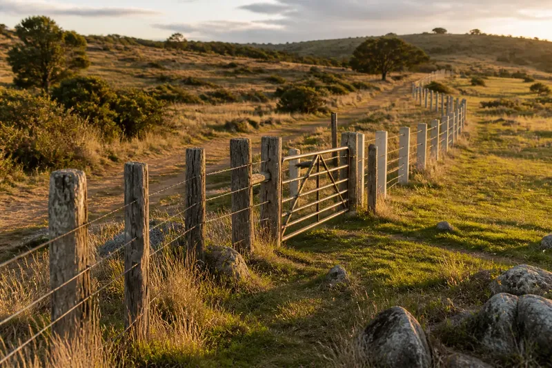
At a bend in a western track, a weathered fence changes direction without changing the slope. One stretch is wire on timber posts; the next follows a line of pale, squared stakes, and a narrow gate faces a patch of grass. A fence line as a record of land use begins here: not with an assumption about ownership, but with the question of what people needed the boundary to do.
Fences make divisions visible, but their purposes can shift. A line may have been built to contain livestock, protect a field, keep animals away from a road, or mark a division that outlasted the use that first called for it. Later repairs can obscure that story, while changes in vegetation and paths may preserve hints. Read the line as a sequence of choices, and it becomes a clue to changing patterns of use rather than a single, settled answer.
What can the fence’s materials tell you?
Begin by noticing what is present, not by assigning a date. Look for changes in post material, wire, spacing, height and condition. Timber posts may stand beside metal ones; a newer strand may run above older wire; a heavy corner post may anchor a lighter stretch. Such differences suggest that the boundary has been maintained or altered, but they do not, on their own, identify when or why.
Materials also reflect practical decisions. A line crossing stony ground may use posts set where the soil allows them to hold. Along a road, a sturdier corner or a reinforced gate may handle repeated opening and closing. A short section made with different materials could be a repair, a change in construction, or a response to a local obstacle. Treat each as a question to carry forward, not a verdict.
It helps to compare several features at once. A new-looking gate in an old line means something different from a continuous run of newer posts. A shift in wire can coincide with a break in slope, a change in vegetation, or the edge of a cultivated patch. The surrounding land gives materials context; the materials, in turn, help make the landscape’s divisions easier to see.
Why does a boundary turn or stop?
A fence rarely follows a perfect abstract line for long. It may bend around a rocky outcrop, take a more direct route across level ground, or meet a track at a gate. These turns can point to obstacles, access needs or the edge of a working area. They can also reflect a later adjustment, especially where an old stretch ends abruptly or a newer one joins it at an awkward angle.
Pay attention to what lies on both sides. If one side has a different grass height, scattered shrubs or signs of regular passage, the line may have separated areas managed in different ways. That contrast might relate to grazing, mowing, cultivation, access or a change in maintenance. None is automatic: weather, soil and shade can also produce visible differences. The useful observation is the contrast itself, followed by a search for other clues.
Where several fence lines meet, note which line continues most clearly and which seems to have been added against it. A junction can indicate that an earlier division was reused, subdivided or made less important. It can also be the result of unrelated boundaries meeting. A map, local records or a land manager’s account may help resolve the question, but even without them, the junction shows that the landscape has been organised more than once.
How can a gate reveal a changing pattern of use?
A gate is a working interruption in a boundary. Its position can connect a field to a road, a track to water, or one enclosed area to another. Look for the approach as well as the gate: a worn path, a clear gap in vegetation or a pair of posts set for easy passage can suggest repeated movement. A gate facing nowhere obvious may point towards a route that has faded, shifted or become unnecessary.
The opening may have changed while the boundary remained. A broad entrance might now be narrowed by a smaller gate; a former opening may be wired shut; a footpath may pass beside a gate intended for vehicles or livestock. These arrangements can register changes in who or what needed to pass. They do not reveal the whole story, but they help distinguish a boundary that simply divides from one that also manages movement.
Imagine a walker following an invented fence beside a broad grassy bench. At first, the line is a low, irregular run of timber posts and wire. Near a track, it meets a heavier gate, then continues with newer metal posts around a smaller enclosure. The walker notices that the older line follows the edge of the bench, while the newer one cuts across it. A path approaches the gate from the track, and the enclosed patch has a different pattern of grazing from the open ground. Taken together, these details make it reasonable to infer that a broad division was later adapted to manage a smaller area and its access. They do not establish the land’s legal status, the exact sequence of changes or the reason for every repair. The useful result is a more careful reading: one boundary, several possible phases of use, and visible evidence that can be checked against other sources.
What questions help make sense of a fence line?
Does an old-looking fence mark an old boundary?
Not necessarily: a fence may have been rebuilt along a boundary that predates its visible materials. Look for supporting clues such as a continuing line in a hedge, ditch, track or field edge, and keep the age of the structure separate from the age of the division.
Can wire and post styles identify a specific use?
They can suggest what the fence was designed to contain or exclude, but local practice and later repairs vary. Read the construction alongside gates, terrain and the land on either side rather than treating one feature as decisive.
What if the fence no longer serves an obvious purpose?
That may be part of its record: an enclosure can remain after its former use has altered or ended. Check whether paths, vegetation or newer boundaries indicate that movement and management have shifted elsewhere.
Should I use a fence line as a property boundary?
No: a visible fence is not, by itself, proof of a legal boundary. For a property or access question, consult the relevant records and a qualified professional; observe fences from places where you are permitted to be.
How do you separate observation from a story?
Write down what you can see before explaining it. “Two wire types meet at a gate” is an observation; “the enclosure was divided for a new grazing arrangement” is an interpretation. Keeping the two apart makes it easier to revise your reading when a map or another feature points in a different direction.
Then ask whether the explanation accounts for the whole line. A claim that a fence managed livestock should fit its continuity, openings and relation to usable ground. If the line stops at a steep bank or crosses an obvious track without a gate, there may be another purpose, a missing section or a later change. A good interpretation can leave room for uncertainty without becoming vague.
Maps can help, but compare them carefully. A mapped boundary may record a legal or administrative division, while a fence on the ground may be newer, displaced or absent. Old aerial images, local plans and field names can add context where available. None should be treated as a perfect translation of the others: each records a different aspect of how land was described or used.
What is useful to record, and what can you skip?
A brief field note is usually more valuable than a long inventory. Record the route you followed, notable changes in construction, turns, junctions, gates, nearby paths and contrasts in the ground cover. A simple sketch can show which features meet, while a map reference helps you return to the right stretch. Photographs, taken from an appropriate public route, can preserve details that are easy to forget.
- Note where materials change and whether the change follows a feature of the terrain.
- Mark openings and observe which routes approach them.
- Compare the land on either side without assuming the fence caused every difference.
- Look for lines that continue as tracks, ditches or vegetation beyond the fence.
- Keep observed details distinct from possible explanations.
It is not worth trying to assign a precise age from weathering alone. Exposure, repairs and the kind of material all affect appearance, and a faded post can sit in a much newer boundary. Nor does every small bend need a special explanation. Focus on changes that connect to other features and help explain how the land was divided, entered or maintained.
How does the fence line change the landscape you see?
A fence makes land use legible by turning an invisible division into a line that can be followed. Yet the line is not the whole history. Its materials may have been replaced, its route adjusted, and its openings repurposed as movement and management changed. Reading these traces together lets you recognise the difference between a lasting boundary and a lasting purpose.
On your next walk, follow one stretch only as far as it remains clear, then note where its logic changes: a gate, a junction, a turn, or a shift in the land. That small habit makes a fence line as a record of land use more than a border on the ground. It becomes a way to ask who or what needed passage, what was being kept apart, and which parts of that arrangement still shape the place today.